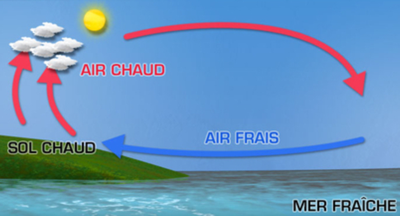
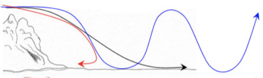
The coastal thermal breezes are related to the interaction water / land: the thermal capacities of water and land are very different, they will therefore heat and cool at different speeds.
The sea is almost stable in temperature over 24 hours, while the land heats up during the day and cools down at night. This difference in temperature is at the origin of the breeze.
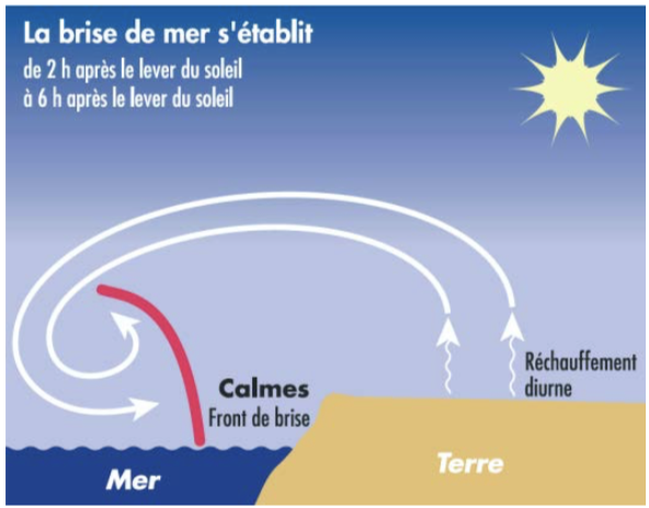
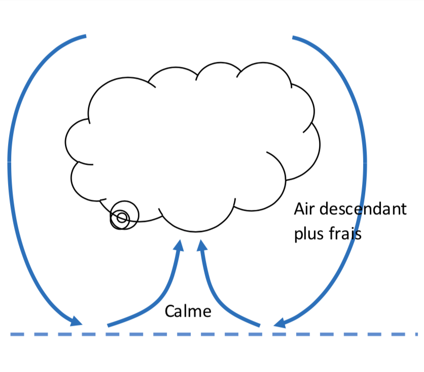
The sun warms the land faster than the sea. The air begins to rise.
This air can be driven by the synoptic wind of altitude (from 1500 to 2000m), the “hot” air leaves towards the sea and cools down: it goes down slowly until it arrives at the surface of the water. This is a convection cell.
The breeze front is a calm zone (convergence of two “opposite” winds). It moves
towards the shore.
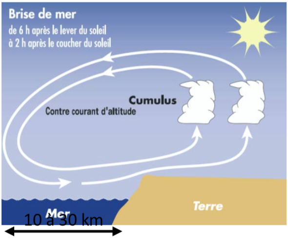
By midday, the first cumulus clouds are present and the breeze begins to set in. The wind is almost perpendicular to the coast
(if the latter is almost straight).
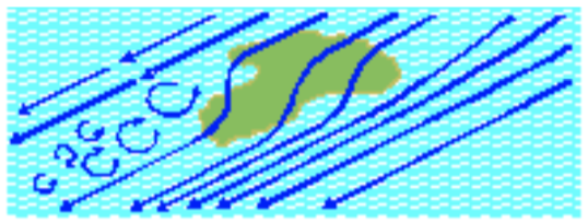
Sea breeze
Once established, the breeze usually stays until sunset. Be careful not to get “trapped” when sailing in breezy conditions (the wind can then diminish well before sunset if the breeze is weak in intensity). Finally, the wind direction turns (to the right) during the day due to the Coriolis force.
Make a diagram to explain the daytime coastal thermal breeze:
Answer
Sea breeze schema
Criteria for establishing a daytime thermal breeze
#
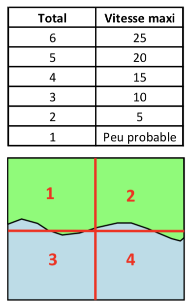
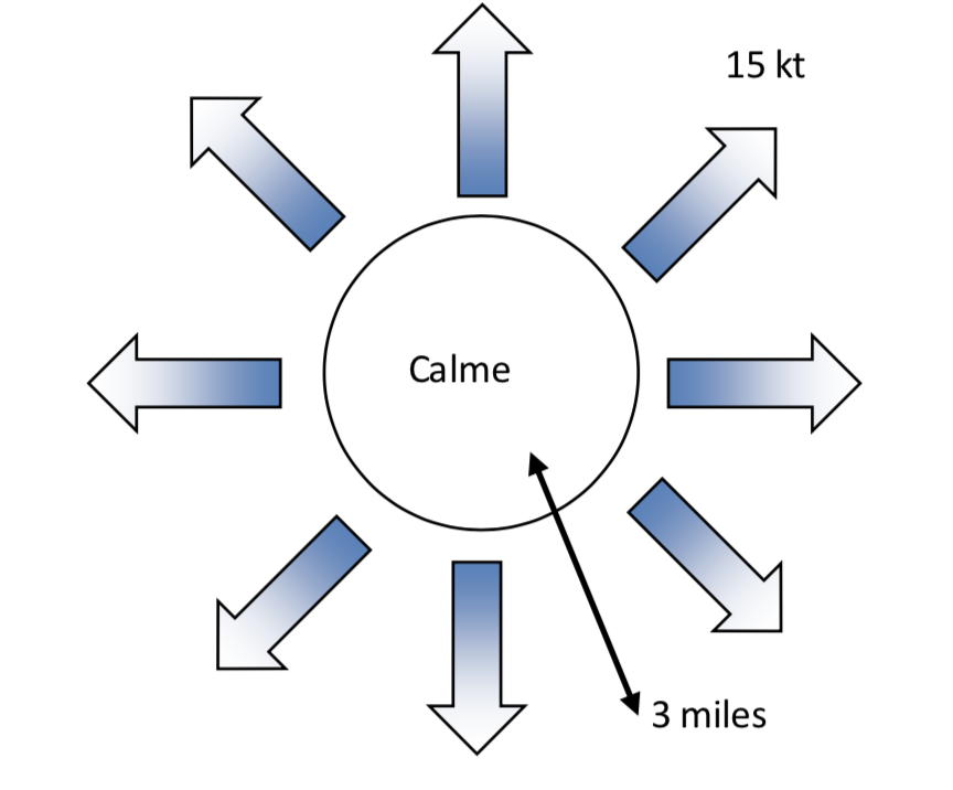
A point system can be used to predict whether the thermal breeze is likely to be established:
Thermal breeze quadrant
If the air temperature is not about 4° higher than the water temperature, thermal breeze is not possible.
If the synoptic wind speed is greater than 16 kts, thermal breeze is not possible.
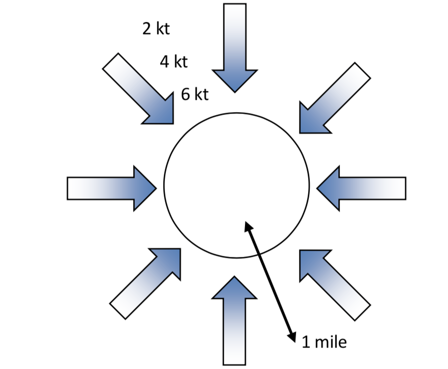
Synoptic wind direction :
Quadrant 1: + 2 points
Quadrant 2: + 1 point
Quadrant 3: - 0 points
Quadrant 4: - 1 point
Air temperature :
Cool: + 1 points
Warm: + 0 points
Hot: - 1 point
Sunshine :
Good: + 1 points
Average: + 0 points
Poor: - 1 point
High tide in the afternoon :
Yes: + 0 points
No: - 1 point
Stability of the air mass :
Unstable: + 2 points
Stable: - 1 points
La présence de cumulus est-elle suffisante pour que s’établisse une brise thermique?
Réponse
Non, les cumulus le long de la côte sont un bon indice mais d’autres critères sont essentiels comme le différentiel de température air/eau et une vitesse de vent synoptique inférieure à 16kts.
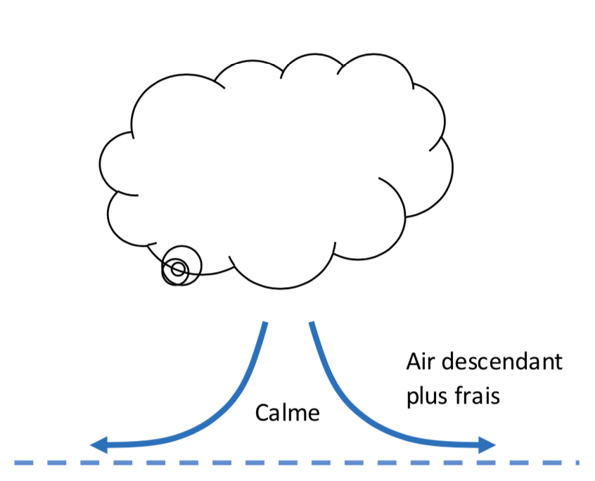
A site effect is due to local geography. There are many of them, some of them being compositions of “elementary” effects. Let’s keep in mind that a cold and therefore dense wind “sticks” more to obstacles than a warm wind (notion of viscosity). Stable air also accentuates the phenomena of site effects.
Effet de pointe
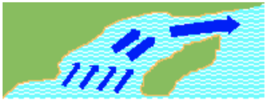
Si le vent vient toucher une pointe sous une direction latérale, il a tendance à diverger de façon radiale. Pour une île, le côté sous le vent est déventé et les côtés extérieurs sont plus ventés (coté bâbord plus venté).
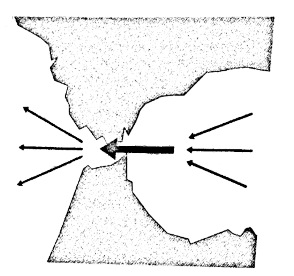
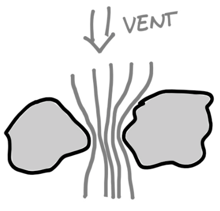
Effet de canalisation
Il se crée un effet Venturi par canalisation. L’accélération commence avant le détroit et continue quelques milles après.
Relief et cours d’eau
Le vent a tendance à suivre globalement la géographie locale. Ainsi sa direction et sa force se trouveront modifiées (effet Venturi).
Les frottements étant plus importants sur terre que sur mer, le vent au-dessus des terres est plus faible. La force de Coriolis est donc moins importante. Le vent sur mer sera donc orienté plus « à droite » que le vent sur terre.
Côte moyennement élevée
Création d’un « coussin » (vent faible et désordonné).
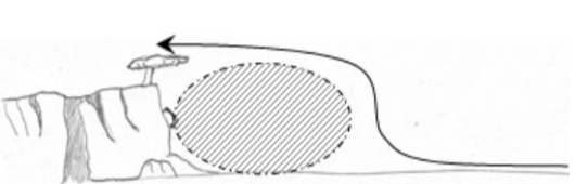
Côtes élevées
Côtes avec relief important, type Côte d’Azur, Corse, Pays Basque): onde de dévent avec possibilité de retour.
Faites un schéma pour illustrer un effet de canalisation local:
Le grain est une variation brusque de la vitesse et/ou de la direction du vent. Il est accompagné le plus souvent d’un nuage fortement convectif de type cumulus congestus (Cc) ou cumulonimbus (Cb). En voile légère, il est fortement déconseillé de naviguer sous un Cb. De fortes rafales de directions variables avec pluie voire grêle sont des conditions habituelles sous un grain. De plus sous un Cb, un éclair peut venir frapper votre embarcation.
Les grains se rencontrent essentiellement juste avant le passage d’un front froid et après son passage (dans la traîne). Une traîne caractérisée d’active a de très grandes chances d’avoir de nombreux grains, voir des lignes de grains. Plus les nuages sont développés verticalement, plus les grains sont violents. Plus la base du nuage est basse et plus le grain sera violent.
Le vent de surface et le vent d’altitude (celui qui pousse le nuage) sont de directions différentes. Le grain aura tendance à avoir une route « plus à droite » que le vent de surface.
Il faut dissocier le cas d’un grain pluvieux et d’un grain non pluvieux.
Pourquoi est-il dangereux de naviguer sous un cumulonimbus en voile légère?:
Réponse
Il est dangereux de naviguer sous un cumulonimbus car il peut y avoir de fortes rafales de direction variables avec de la pluie voire de la grêle. Si un orage est présent, un éclair peut venir frapper le bateau.
Quand a t’on le plus de chance de rencontrer un grain?
Réponse
Juste avant le passage d’un front froid et après son passage (dans la traîne).