Definition #
It is a region of the troposphere constituting a dynamic and thermal transition zone between two air masses different by their characteristics. Source : Météo-France A front is a surface of discontinuity (transition zone) where two air masses with different properties confront each other. There are different types of fronts:
- warm fronts,
- cold fronts,
- occluded fronts,
- stationary fronts.
Front schema
Representing fronts on maps #
Here are the official symbols used to represent fronts on color or black and white weather maps.
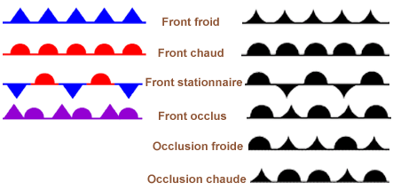
Front symbol
Representation of the different fronts on the AEROWEB site of METEO-FRANCE #
Active fronts. #
- 1 cold front - 2 warm front - 3 occluded front - 4 quasi-stationary front

Perturbation active fronts
Not very active cold fronts #

Perturbation little active cold fronts
Warm fronts not very active #

Warm front disturbance not very active
Near-stationary fronts #

Perturbation quasi-stationary front
Warm front #
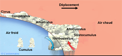
A warm front is a boundary between two air masses, such that warm air being located behind the boundary, replaces cold air. The warm air having a lower density than the cold air, is forced to rise above the cold air. Unlike the cold front, the passage between the two air masses takes place over a long distance and it is sometimes difficult to note the exact moment of its passage. The approach of such a front is marked by an invasion of high cirrus clouds, which gradually increase in thickness and turn into altostratus. Then the cloud becomes nimbostratus and gives continuous precipitation.
Stable warm front #
Main clouds :
- Cirrus
- Cirrostratus
- Altocumulus
- Altostratus
- Nimbostratus
- Stratocumulus
- Stratus
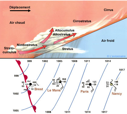
Stable Warm Front
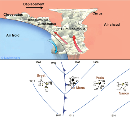
Unstable warm front #
Main clouds :
- Cirrus
- Cirrostratus
- Altocumulus
- Altostratus
- Cumulonimbus
- Nimbostratus
- Stratus
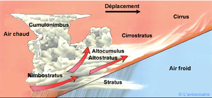
Unstable Warm Front
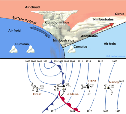
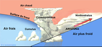
Cold Front #
There are several types of cold fronts. A cold front is a boundary between two air masses, the cold air being located behind the boundary in the direction of movement, engages under a mass of warm air by pushing it. This front marks a zone of spatial variation on the earth’s surface ra
Stable cold front #
Main clouds:
- Cirrus
- Cirrostratus
- Altostratus
- Altocumulus
- Nimbostratus
- Stratocumulus
Stable cold front
Unstable cold front #
Main clouds:
- Cirrus
- Cirrostratus
- Altocumulus
- Altostratus
- Cumulonimbus
Unstable cold front
Anabatic cold front or anafront #
The cold air will very actively push back the preceding warm air and lift it to a great depth along the frontal slope, which is strongly inclined. Precipitation then occurs mainly behind the ground track of the cold front. The upper jet stream is roughly parallel to the frontal slope and some distance back from it aloft and is the rearward limit of vertical motion. Front anafront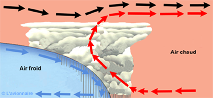
Catabatic cold front or catafront #
On the contrary, in a cold catafront, an intrusion of dry air in altitude comes to cut the ascents in the warm air, which causes the dissolution of clouds at these levels. In this case, most of the clouds and precipitation appear in front of the frontal trace on the ground. The upper jet stream will be rather perpendicular to the frontal slope. Front catafront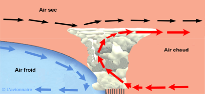
Secondary cold front #
It happens that a very cold air from the pole (cold drop) lifts the cold air behind the disturbance and forms a second cold front. This lifting increases the instability and generates sometimes heavy showers but also cumulonimbus which can be transformed into squall line. Secondary cold front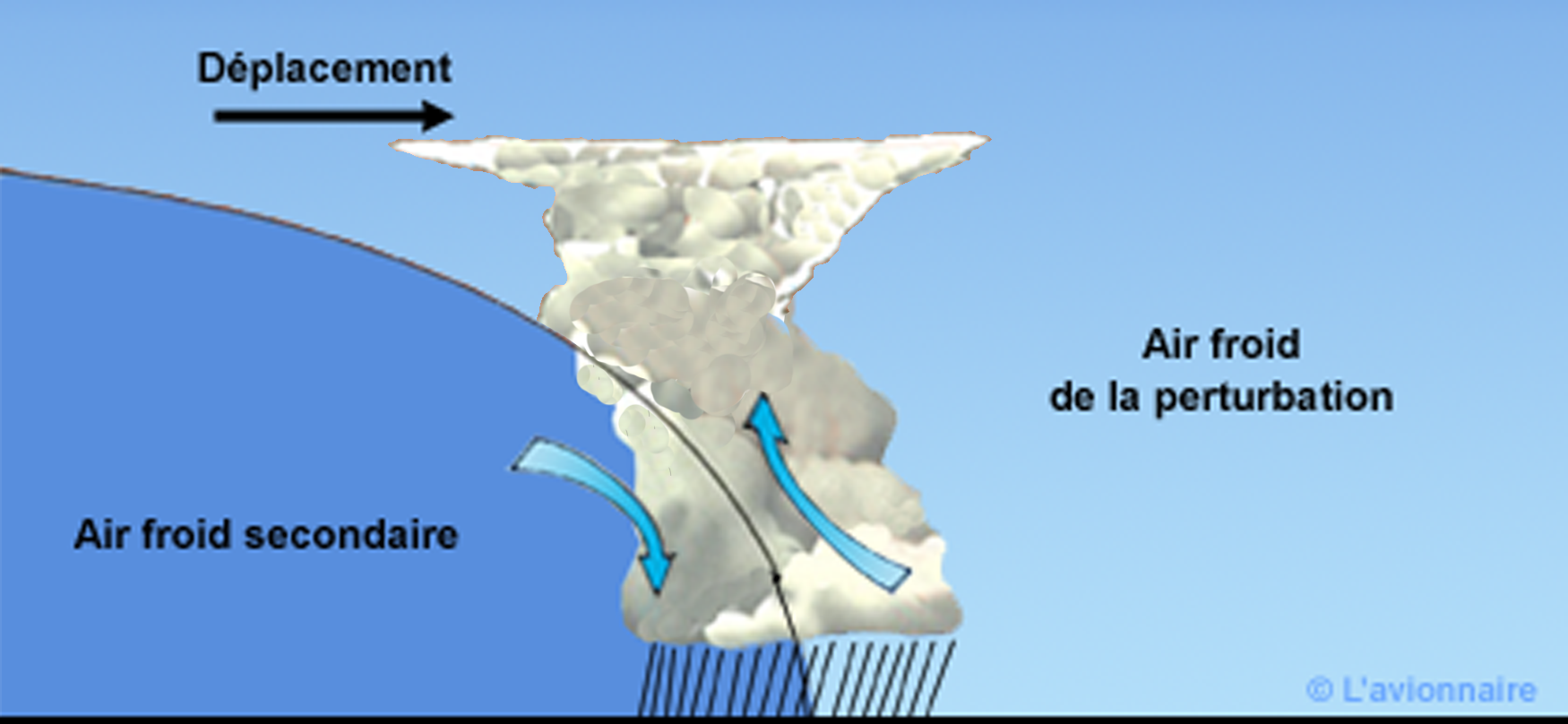
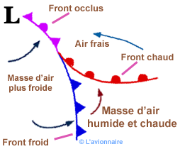
Occluded front #
An occluded front or occlusion is when the faster cold front has joined the warm front in the circulation of a disturbance. As the cold front reaches the warm front, the warm air becomes increasingly pinched or trapped between the two fronts. It will be lifted aloft and the system becomes occluded. There can be two types of occluded fronts:
Cold occlusion #
When the frontal part of the cold air is colder and denser than the fresh air mass in front of the warm front. Thus it insinuates itself not only under the warm frontal mass but also under the fresh air mass in front of the warm front, forcing these two elements to rise, we then have a cold front occlusion. The base of the upper warm air trough is behind the occlusion at the surface.
Cold occluded front
Warm occlusion #
When the situation is reversed, the frontal portion of the cold air is less cold than the air mass ahead of the warm front. The cold front rises along the warm frontal surface, and is rejected aloft by the colder air in front. We then have an occlusion with a warm front character. The base precedes the surface front. In countries that use the term “upper or upper front”, rather than trowal, it is specified that the occluded front is cold or warm.
Warm occluded front
Stationary front #
Stationary fronts form when two air masses with different characteristics meet but do not flow toward each other. They find themselves sliding past each other under the upper atmospheric circulation. These fronts can remain stationary for several days; then they can either break up (becoming shear lines) or become a warm front or a cold front, depending on a change in the upper flow. Due to the fact that the two air masses they separate slide relative to each other, there is little vertical movement along stationary fronts. They are therefore usually associated with partly cloudy or cloudy weather and light precipitation.